
Govt opting for technology to maintain highways as landslides pose challenge
By Arun Kumar Das
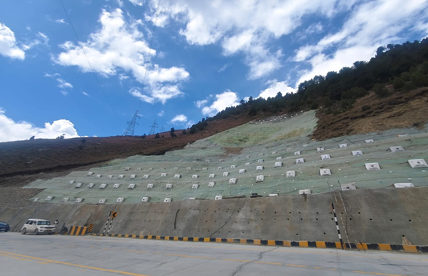
New Delhi, Jun 14: As climatic disasters like landslides have become more frequent, the Ministry of Road Transport and Highways (MoRTH) is turning to advanced technologies to safeguard critical road infrastructure in the country’s most vulnerable terrains.
Among these measures is the deployment of Interferometric Synthetic Aperture Radar (InSAR)-based landslide monitoring and early warning systems along a 100-km stretch of the Char Dham route in Uttarakhand, enabling authorities to detect subtle ground movements and identify vulnerable slopes before disaster strikes.
Complementing this effort are plans for an advanced warning and alert system on the Parwanoo-Solan section of NH-5 in Himachal Pradesh to monitor landslides, land sinking, groundwater movement and rockfall-prone zones in real time, according to the ministry officials.
Together, these initiatives by the Ministry reflect a broader shift from responding to disasters after they occur to predicting and preventing them, helping build a safer and more resilient highway network across India’s hill states.
Building resilient highways in geologically sensitive regions requires not only engineering expertise but also a deep understanding of the terrain itself.
Also Read:
Among the many initiatives, MoRTH has strengthened institutional collaboration with scientific agencies, including signing an MoU with the Geological Survey of India (GSI) for geological investigations of tunnel projects and data sharing for geohazard studies, its officials say.
To enhance the safety and structural integrity of road tunnels, geological maps and National Landslide Susceptibility Mapping prepared by GSI are now being integrated into the planning and alignment survey stages of national highway projects in fragile hilly landscapes.
With nearly 16,788 km of National Highways in India’s hill states out of a total NH network exceeding 1,46,570 km, building infrastructure that is safe, reliable and resilient to natural hazards has become more important than ever.
The Himalayan region, one of the youngest mountain ranges in the world, is particularly vulnerable to landslides, rockfalls, flash floods, cloudbursts and other geohazards.
Strengthening Highway Construction Practices
To improve the sustainability of road projects in the hills, MoRTH has introduced several policy reforms.
A phased construction approach is now being adopted, wherein construction will take place in stages, with the initial period of about one year to be dedicated solely for the cutting of hill slopes and completion of protection works for stabilization of the slopes.
Road construction begins only after slopes demonstrate stability through at least one monsoon season.
Making use of geospatial intelligence for real decision-making, MoRTH has signed MoUs with companies using advanced satellite-based monitoring technologies to detect subtle ground movements long before landslides and slope failure occur.
Through periodic and continuous analysis of satellite data, their technology helps provide early warning indicators, support targeted mitigation measures and improve maintenance planning.
As part of this, MoRTH is piloting the InSAR technology for landslide monitoring along the Char Dham route in Uttarakhand.
The initiative assumes greater significance considering that mountain highways typically cost between ₹15-30 crore per km to construct.
A single moderate landslide can lead to repair costs of ₹10-25 crore and disrupt traffic movement for 2-5 days.
By facilitating timely interventions and reducing the likelihood of major slope failures, satellite-based monitoring has the potential to lower maintenance costs, minimise disruptions and enhance the resilience, safety and reliability of National Highways across the country’s landslide-prone hill states.
MoRTH has also introduced a policy on Normative Construction Periods that provides additional time for projects in regions such as the Himalayas, the North-East, the Western Ghats and the Andaman & Nicobar Islands.
Additional Right of Way is also being provided with adequate land being provisioned to facilitate proper slope stabilization and maintenance activities. (BVI)